2025 Harvest Weather Outlook
Written by: Andrew Welch, Sustainable Agronomist at ForGround by Bayer, and the experts at BAM Weather
We’ve teamed up with BAM Weather meteorologists to bring you a detailed, region-specific weather report for the 2025 harvest season.
Key Insights
-
Dry conditions are expanding across the Eastern Agricultural Belt, particularly in Northern Indiana, Illinois, Ohio, and Southern Michigan, with some areas ranking in the bottom 10th percentile for soil moisture. Conversely, the Western Coast and Southwestern US are experiencing better soil moisture levels in the top 20th percentile, while recent rains in the Northern and Central Plains have kept soil moisture relatively normal.
-
Above-normal temperatures are expected across much of the Agricultural Belt, delaying the first freeze in many areas. A few cold fronts in mid to late October may bring seasonal temperatures and increase freeze risks, particularly in the Western Plains.
-
The second half of October may see rain opportunities in the Plains due to cold fronts, but rain chances will be sporadic in the Eastern Agricultural Belt and Southeastern US, leading to below-normal precipitation in these areas and potentially worsening drought conditions.
-
The forecast for late 2025 indicates a weak La Nina, which may contribute to warmer than normal temperatures in the central and eastern US during fall. Looking ahead to November, above-normal temperatures are expected across the Eastern and Southern US, while below-normal temperatures may be more prevalent in the Northern and Western Plains.
Soil Moisture & First Freeze Timelines
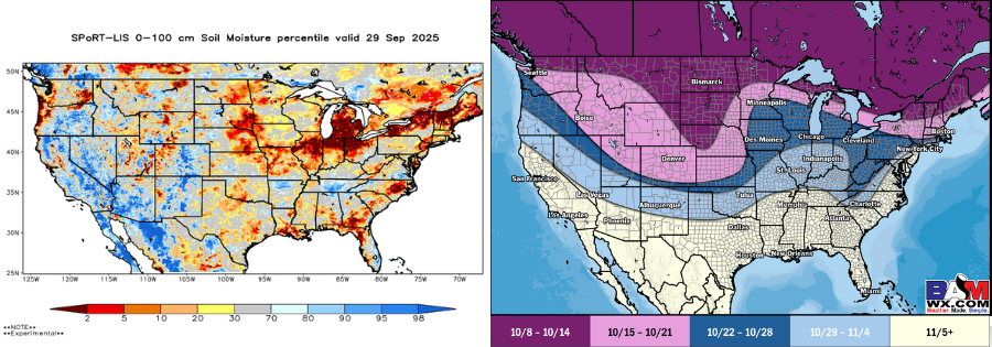
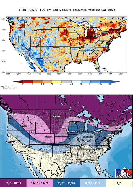
Soil Moisture
Here is a look at the top 3 feet (100 cm) of soil moisture (in terms of percentiles) for this time of year. Key observations include expanding dry conditions compared to this time last month across the E Ag Belt (especially N IN, IL, OH and S MI), with portions ranking in the bottom 10th percentile (very dry). Areas that continue to see somewhat better soil moisture in the top 20th percentile (wet soil) include portions of the W Coast and into the SW US. While still drier overall, recent rains in the Northern/Central Plains have allowed for soil moisture to remain relatively normal compared to last month.
Precipitation
Here is a look at our latest thinking on first freeze timeframes for the country. With above/much above normal temperatures being present across much of the Ag Belt, this will allow for many areas to see later than normal first freeze risks. A few cold fronts mid/late October can allow for returns to seasonal/slightly below normal temps and present these freeze risks.
Mid/Late October Temperature & Precipitation Outlook
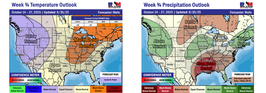
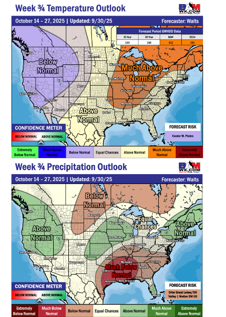
Temperature
Here is the temperature forecast for mid/late October. The core of warmth for the second half of the month will tend to settle across the Eastern Ag Belt, Great Lakes, and up through the Northeast US as cold fronts will struggle to work further east of the Plains. Depending on the strength/frequency of fronts in this window, cooler risks will be present at least across the Western Plains.
Precipitation
For precipitation for the second half of October, the fronts mentioned above will allow for rain opportunities to be present across the Plains. However, due to the fronts having the tendency to struggle to work further east, rain chances will become more sporadic into the E Ag Belt and SE US. This will allow for below normal rain chances across the lower OH Valley and into the SE US.
October Temperature & Precipitation Outlook
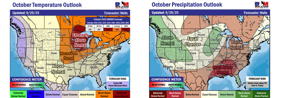
Temperature
As we take a look at October as a whole, warmth will be the theme across much of the country, especially with much above normal temperatures being rather widespread across the Ag Belt in the first 7-10 days of the month. The most extreme warmth will look to settle in the Upper Midwest and Great Lakes regions. While there will be some subtle cold fronts across the Ag Belt in October, warmth will overall be dominant with the coolest temperatures wanting to work more so into the W Plains and W United States.
Precipitation
Precipitation for the month of October will hold below normal rain chances across the eastern United States with the driest conditions settling in the Gulf Coast/SE US. This can lead to rapidly increasing drought conditions. With the risk of cold fronts in the Northwest Plains mentioned above, this can allow for some wetter signals across the Upper Midwest/Central Plains, especially mid-late month. While there still will be rain opportunities into the E Ag Belt, the better precipitation risks will be further into the Plains.
Model Predictions
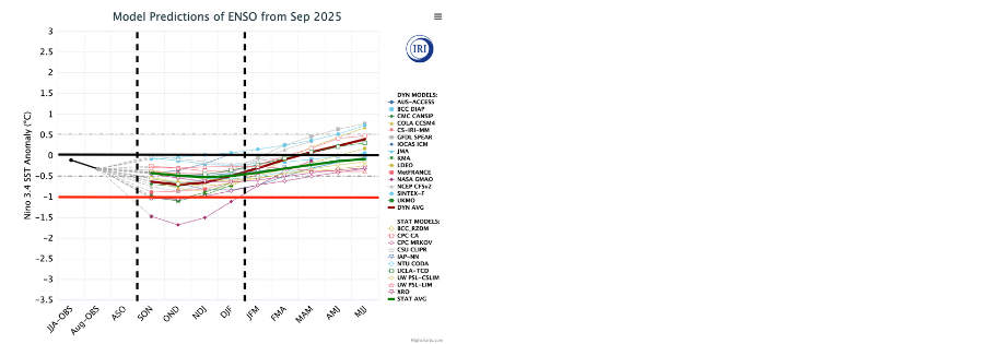
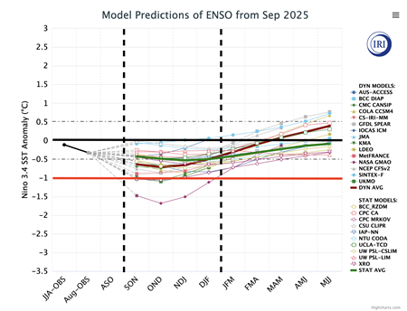
Model Predictions
As we work into the end of 2025, we continue to watch the evolution of El Nino / La Nina. The majority of the data is settling between the black and red lines, which continues to suggest a cool neutral/weak La Nina, with the lean at this time being a weak La Nina. This progression of the “ENSO” cycle would look to continue favoring warmer than normal temperatures for the end of fall across much of the central/eastern US. Once we get into December however, this would help to aid in below normal temperatures starting to work into the northern half of the country, pushing the warmth into the southern United States.
November Temperature & Precipitation Outlook
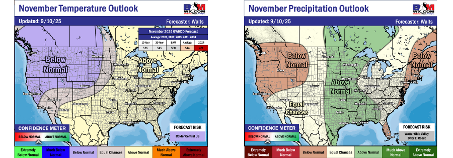
November Temperature
Looking ahead to November, above normal temperatures will look to once again be the theme across the Eastern/Southern US. While there can be some cold fronts/brief cool downs mixed in, the better chances for cooler temperatures will look to be into the Northern/Western Plains. Areas such as the Western/Northwest US will be where below normal temperatures can look to be more favorable.
November Precipitation
The map above outlines the latest thinking precip wise for the month of November. Overall, the central portion of the country is where rain chances will look to be more favorable throughout the month with below normal rain chances continuing along the East Coast. What will need to be monitored is how far east these rain chances in the Central US/Plains can work, with the risk of a messier precip pattern overall for the E Ag Belt/OH Valley in November.
Winter Outlook
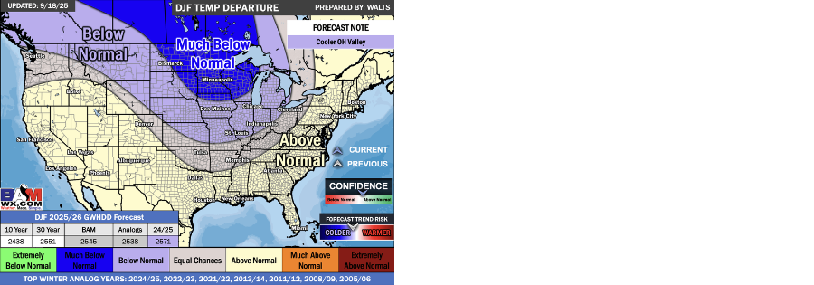
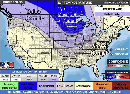
Winter 2025-2026
The above map represents our current thinking for Winter temperatures for 2025-2026. The general idea is that below normal temperatures will be able to settle across much of the Ag Belt, with the most prominent cold averaged out across the Upper Midwest/Northern Plains. While there can be cold shots into the Southern US/East Coast for winter, the general theme will be warmer than normal temperatures throughout the season. We will note that the start of Winter (December/beginning of January) can look to be cooler compared to the back half of winter, especially in the Ag Belt.
About the Report:
This report isn't just a forecast; it's a helpful tool to make informed decisions for your farm. As a member of ForGround by Bayer, you'll get a weather forecast just like this delivered straight to your inbox every month. Plus, no matter where you are on your regenerative agriculture journey, with ForGround, you will gain year-round access to science-based agronomic support, insights, and discounts, and will be the first to know when new potential revenue streams arise.
Did you know? ForGround members can now claim an exclusive 20% discount on a BAM Weather Clarity Starter or Clarity Pro subscription for one year. Learn more