
2025 Early Fall Weather Outlook
Written by: Andrew Welch, Sustainable Agronomist at ForGround by Bayer, and the experts at BAM Weather
We’ve teamed up with BAM Weather meteorologists to bring you a detailed, region-specific weather report for early fall 2025.
Key Insights
- Current soil moisture conditions show increasing dryness in the Northern and Central Plains, as well as the Ohio Valley and Great Lakes, with some areas in the bottom 20th percentile for moisture. In contrast, the West Coast and parts of the Deep South/Southeast remain wetter, ranking in the top 20th percentile.
- As fall approaches, the influence of El Niño/La Niña suggests a cooler Eastern US and a warmer Western/Northern US, with drier conditions in the South and more volatile precipitation in the Ag Belt.
- For October, above-normal temperatures are anticipated in the Ag Belt and Northern US, while the Southeast may experience cooler conditions. Precipitation patterns will be mixed, with drier conditions expected in the Central Plains and Upper Midwest, and the Gulf and East Coasts remaining persistently dry.
Soil Moisture & First Frost Timelines

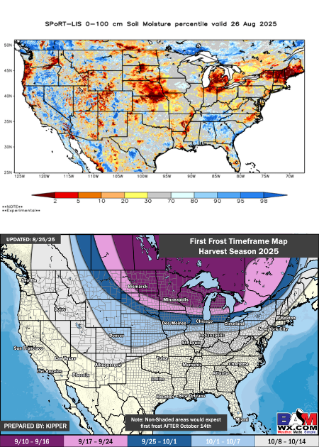
Soil Moisture
Here is a look at the top 3 feet (100 cm) of soil moisture (in terms of percentiles) for this time of year. Key observations include increasing dry conditions compared to this time last month across the Northern/Central Plains and into the OH Valley/Great Lakes, with portions ranking in the bottom 20th percentile (very dry). Areas that continue to see somewhat better soil moisture in the top 20th percentile (wet soil) include portions of the W Coast and through the Deep South/Southeast US.
Precipitation
Here is a look at our latest thinking on first frost timeframes for the country. With multiple stronger colder fronts for mid-September, we are noting the risk of earlier than normal frost concerns across the Upper Midwest, Great Lakes, and Northern Plains. The further south we get, generally South of I-80, these mid-September cold fronts will not look to be as pronounced, allowing for more seasonable/slightly later than normal first frost dates.
Early September Temperature & Precipitation Outlook

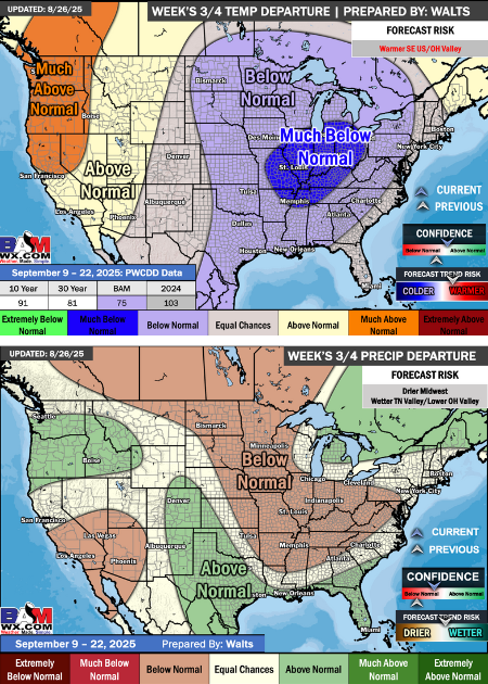
Temperature
Here is the temperature forecast for mid-September. The stronger cold fronts mentioned above will allow much of the Ag Belt/Eastern US to average out below/much below normal for this timeframe with warmer temperatures being suppressed to the Western US. We are noting more seasonal/slightly above normal temperatures to work back into the area towards the end of the period, with a quicker progression can allow for warmer SE US/OH Valley.
Precipitation
As the cold fronts move through the Ag Belt in mid-September, this will present below normal precip chances (although not completely void of rain) for these areas. The stronger cold fronts will push better rain opportunities into the South Central US and along the Gulf Coast. Seasonal/above normal precip chances can also be seen into the Great Lakes and NE US on the E/NE side of where the core of the stronger cold fronts are.
September Temperature & Precipitation Outlook

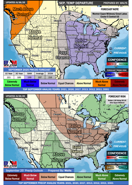
Temperature
As we take a look at September as a whole, below normal temperatures will be the dominant factor across the Eastern half of the United States with above normal temperatures across the Western US and bleeding into the NE US. With the warmer temperatures being favored to work back into the Ag Belt towards the end of the month, this can allow for the below normal temperatures overall to be pushed southward. This would allow for the risk of the Upper Midwest/Great Lakes to trend warmer and more seasonable overall.
Precipitation
Once averaged out, September will be able to see below normal precip chances stretching from the Canadian Prairies through the E Ag Belt and Mid Atlantic. Just like mid-September, the month overall will not be completely void of rain with better rain chances towards the end of the month. The Southern/Western US along with the NE/Great Lakes will be areas that will be able to see more seasonal/above normal precipitation chances.
Model Predictions

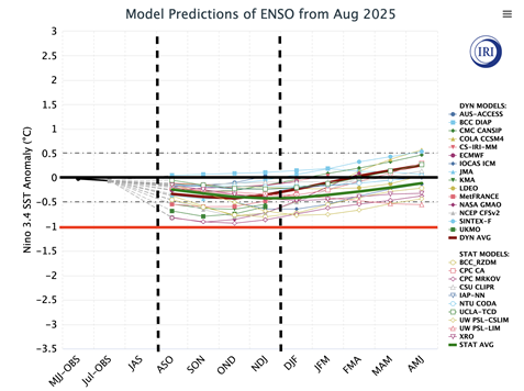
Model Predictions
As we work into fall, we continue to watch the evolution of El Nino / La Nina. The majority of the data is settling between the black and red lines, which continues to suggest a cool neutral/weak La Nina. This progression of the “ENSO” cycle would look to favor a warmer Western/Northern US with a cooler/more seasonable Eastern US. This evolution would look to favor a drier Southern US/East Coast with more volatile precip chances across the Ag Belt.
October Temperature & Precipitation Outlook

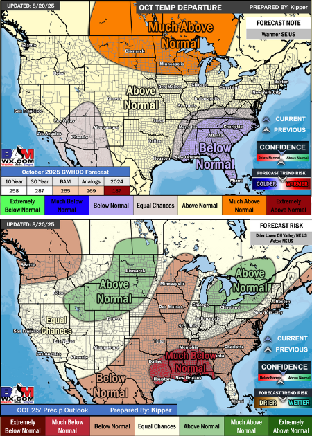
October Temperature
Looking ahead at October temperatures wise, we continue to note above normal temperatures across the Ag Belt along with the Northern half of the country. The core of the warmth for October will look to be settled into the Northern Plains/Upper Midwest/Canadian Prairies. Where temperatures can remain cooler/more seasonal will be the SE US, with periods of ups/downs in the E Ag Belt/OH Valley.
October Precipitation
The map above outlines the latest thinking precip wise for the month of October. Overall, the Ag Belt will look to be a messier set up with no one area being completely dry/persistently wet. Areas that can look to average out drier than normal, however, will be across the Central Plains and through the Upper Midwest. Outside of the Ag Belt, the Gulf Coast and East Coast will look to be areas where moisture will be harder to come by and be more persistently dry.
Winter Outlook

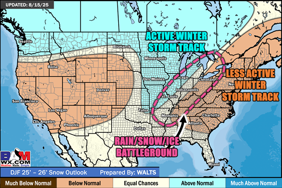
Snow Chances
The above map represents our current thinking for snow chances during the winter season. The general idea is that coupled with below normal temperatures, the more favorable areas for snow will be the NW US, Upper Midwest, and through the Great Lakes. Locations in the OH/TN Valleys will be seeing more volatile temperatures that will allow for more of a battleground of precip types. Nonetheless, in terms of moisture, the Ag Belt and into the TN Valley will be favorable for above normal precip chances in the winter with below normal chances along both coasts.
About the Report:
This report isn't just a forecast; it's a helpful tool to make informed decisions for your farm. As a member of ForGround by Bayer, you'll get a weather forecast just like this delivered straight to your inbox every month. Plus, no matter where you are on your regenerative agriculture journey, with ForGround, you will gain year-round access to science-based agronomic support, insights, and discounts, and will be the first to know when new potential revenue streams arise.
Did you know? ForGround members can now claim an exclusive 20% discount on a BAM Weather Clarity Starter or Clarity Pro subscription for one year. Learn more